Archrival wrote:Dont know what BOC is doing out on that island...
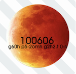
Its geogaddian cordinates
One degree is 60 minutes, then g60h means thats its 60 degrees and p5-2omh means 0,5-0,2 degrees. Latitude 60,5 - 0,2 = 60,3 degrees (north latitude) g2h2 Longitude 2,2 degrees .t 0-n dont know what t 0-n is...
If you look at latitude 60,3 degrees north and longitude 2,2 degrees west is FOULA, a little island west of the Shetland Islands (Scotland).
(On latitude 60.3degrees north latitude and longitude 2,2 east its nothing but the sea)
http://en.wikipedia.org/wiki/Foula
I really dont undertand this logic. And what about the rest of the code?! the 3 lines on the flashing eyes?! all nonsense?
Archival, I'd like to believe this, but I have to say its a bit half baked...